Viewing a map while reading is a great way to boost comprehension, but trying to find a locations on a map that’s on a small device is challenging, having a lot of maps takes up space, and having to stop reading each time you come to an unknown place name to search for it on a map is tedious.
But if there were a “Map View” option where users could see a relevant map in half of the screen:
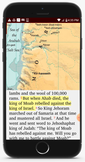
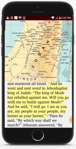
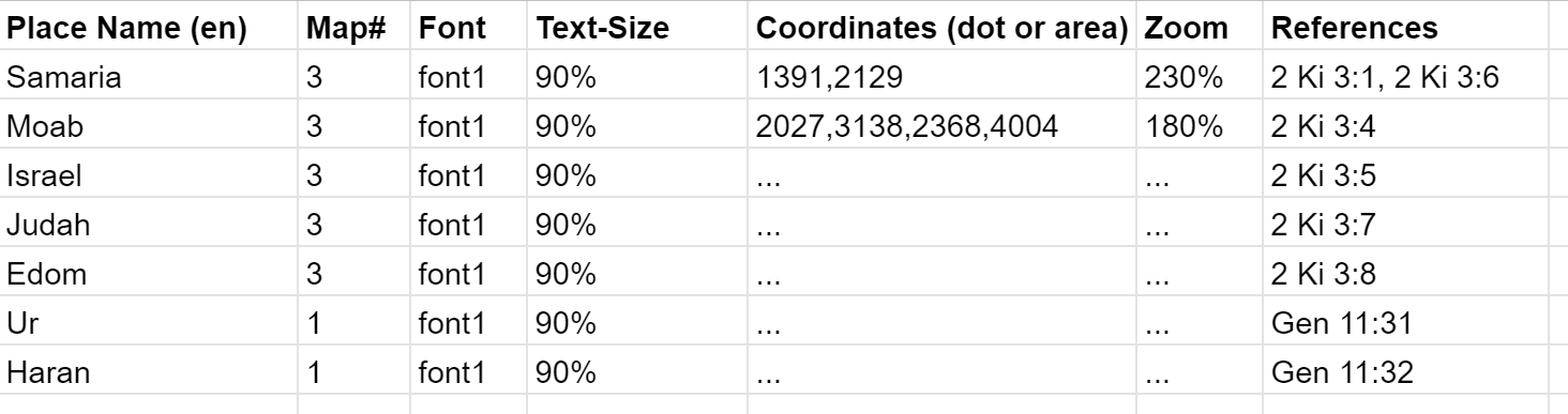
Might there be a way to connect a map to timing files so that when a certain verse is reached, the map pans and zooms to certain coordinates (or when not listening to audio, if a verse is clicked on while in “Map View”)? i.e. a verse mentioning “Samaria” would make the map pan an zoom so that Samaria would be in the center of the map, this way the user gets a better “big picture” of where everything is in relation to everything else
6-7 nice detailed maps could serve for the whole Bible and save space (Genesis: Mesopotamia | 1 Kings - Malachi: Israel and Judah | Ex - Deut: Egypt to Canaan | Gospels: Palestine | Josh - 2 Sam: Canaan | Acts: Mediterranean)
Is it possible for maps to be translatable? (Similar to the interface feature where additional languages could be added)
This sounds really great. I’ve wondered about something like this a lot as I’ve read through passages with lots of place names. Some would obviously be more vague than others, since exact locations are not always known, but it is a great idea.
A similar thing could be done for genealogies or temple-building descriptions. They can be really difficult to follow, but having visuals to track along with the text could be really helpful.
This would be a wonderful feature. Until it is implemented, you could make videos like your mock up and insert these in the text. If you do make map videos please share them here for other SAB developers to see and perhaps ask you if they can be included in their app.
Thanks for the encouragement! I don’t plan to make videos, since I don’t actually own maps (the mock-up video clip was just for visualizing the feature idea).
Also, where I’ve done apps the internet access and phone storage is limited enough that I don’t include videos. This feature idea is just expounding on the existing Picture Book feature of saving space by using a picture that pans and zooms to serve as a “video” for a few verses/sentences. If each map were as detailed as an atlas map, each panning and zooming map “video” could serve for several bible books (while just taking the space of one high-quality bitmap image or a vector image).
I tried adding a map to an app today using the storybook option. My experiment failed because the picture would only fill half of the screen. To create the map, I used a program called Map Creator. Maps created using the program are publishable as long as the proper credits, included in the program’s help file, are included.
If this feature were added, Map Creator might be a reasonable way to get content for apps.